Ice-age geoheritage
The last ice age began around 2.6 million years ago and ended around 10,000 years ago. Geologists define this period as the Pleistocene Epoch. Although often informally known as the Ice Age, the world was not literally shrouded in ice during this time: colder glacial periods alternated with warmer interglacial periods. Evidence of 14–16 glacial periods can be found in Iceland in sedimentary strata and rock formations in the terrain, for example in Jökuldalur and Borgarfjörður in East Iceland and in the Tjörnes sequence north of Húsavík.
Most of Iceland was covered by glaciers during the glacial periods of the Pleistocene. Frost wedging was highly active during the bitter cold of the glacial periods, but certain locations are believed to have remained ice-free for long stretches at a time, for example taller mountains and peninsulas jutting out into the ocean. As a result, the bedrock in such locations is often cracked and fragmented, highly porous, and even instable where the terrain is steep.
Ice-age geoheritage is defined as the traces or remains of geological phenomena that formed more than 10,000 years ago, when glacier ice partially or completely covered the land. In Iceland, this geological legacy includes bedrock formations of various types, marks of ancient bedrock erosion, and relics of subglacial volcanism. The oldest ice-age geoheritage dates back 4–5 million years: tillite strata that can be identified between lava strata in stratigraphic sections.
The most conspicuous features constituting ice-age geoheritage in Iceland date from the last glacial period, which began around 100,000 years ago. The majority of these, and the most prominent, are from the end of the Pleistocene, around 10,000–15,000 years ago, when the environment and climate gradually became more similar to that with which we are familiar today.
The following constitute ice-age geoheritage in Iceland:
- Glacial debris and landforms that glaciers have created from debris, for example terminal moraines, drumlins, and fluted moraines, which provide evidence of the existence, direction, and driving force of the ice streams of ice-age glaciers.
- Glacial erratics are particularly noticeable features in some highland areas. The Icelandic word for erratic, Grettistak (‘Grettir boulder’), is a reference to the famously strong outlaw-hero Grettir Ásmundarson of Grettis saga. These rocks and boulders, some of them enormous, were transported and deposited in the landscape by ancient glaciers rather than legendary heroes.
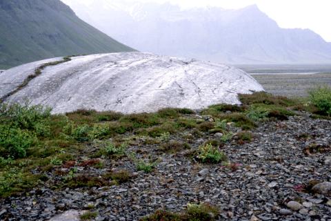
- Glacial stria, sheepbacks (roches moutonnées), and niches are examples of erosional forms in the bedrock that bear witness to the ice-flow direction and the great erosive power of the ice-age glaciers. In a few locations, such as Melrakkaslétta in Northeast Iceland, one can find glacial stria with two to three different directions. This indicates that the ice divide (the boundary separating opposing directions of ice flow) shifted – and thereby that the direction of glacial movement was also altered – due to changes in the size and extent of the ice-age glacier.
- Larger formations and landscape features in the bedrock, including most valleys and fjords, are carved and shaped by glaciers over the course of many successive glaciations, with the assistance of water, frost-weathering, and debris flow activity.
- Hyaloclastite formations, such as ridges and table mountains, form during subglacial eruptions. Such formations are much in evidence in Iceland’s volcanic zones. They can provide information on the extent and thickness of the glacier covering them at the time of their formation.
