Geological maps
The IINH researches and maps the bedrock and loose strata (surficial deposits) of Iceland. Geology maps published by the IINH are of various different types, but they have in common that they provide information on the formation and geomorphology of Iceland and the age and composition of strata. The data used to create these maps come from numerous geologists, often as part of collaborations with other institutes.
In addition to these geology maps, a number of specialised maps of specific areas have been published. These include landslide maps, geomorphological maps, and a geological map of Surtsey.
Bedrock geology

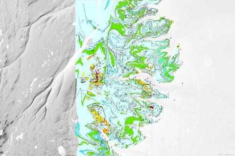
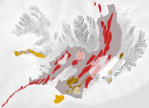
This map at a scale of 1:600,000 broadly outlines the bedrock geology of Iceland. Bedrock is classified on the basis of its age, type, and composition. The map also illustrates the position of volcanic zones in Iceland and the distribution of Holocene eruption sites. Postglacial lavas are divided into prehistoric and historic lavas.
The author of the map is Haukur Jóhannesson. The most recent edition is from 2014.
A printed version can be bought at Forlagið Bookshop.
Tectonics

This tectonic map at a scale of 1:600,000 shows the geology of Iceland in an innovative manner. Strata are classified by age but not by type or composition. The tectonic map shows the position of volcanic systems, dyke and fault swarms, and active and extinct fissure swarms. The map also outlines fracture zones in Iceland and dip of strata.
The map’s authors are Haukur Jóhannesson and Kristján Sæmundsson. The most recent edition is from 2009.
A printed version can be bought at Forlagið Bookshop.
Geological Map of Eastern Iceland
The Geological Map of Eastern Iceland at a scale of 1:100,000 covers the area from Berufjörður to Seyðisfjörður. Bedrock is classified by type and composition. The map shows ancient central volcanoes, tuff layers, craters, caldera rims, fissures, faults, strike and dip, landslides, fossils, springs, and the base of magnetic chron C5n (10.9 Ma).
The map is accompanied by a detailed stratigraphic section and four thematic maps showing dilatation, dip of strata, and the distribution of amygdale minerals and lava types. The location of points of geological interest is indicated on the map, which is accompanied by descriptions and photographs of them.
The author of the map is Birgir V. Óskarsson. The map was published in 2019.
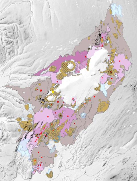
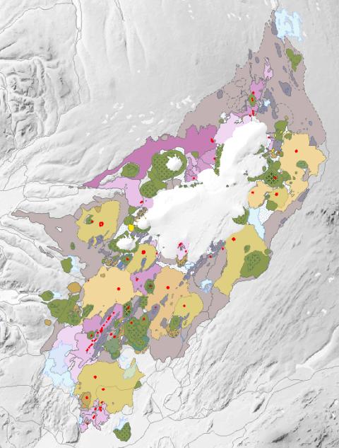
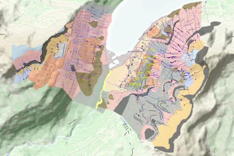
Geological Map of the Western Volcanic Zone (IINH/Iceland GeoSurvey)
The Geological Map of Iceland‘s Western Volcanic Zone at a scale of 1:100,000 shows bedrock geology and unconsolidated sediments, volcanic craters, tectonics, strike and dips, landslides and collapse pits, fossils, glacial striations, glacial moraines, flutes, eskers and ancient lake strandlines. Bedrock is classified by age, type, and composition. The map is the product of a collaboration between the Icelandic Institute of Natural History and the Iceland Geosurvey.
The authors of the map are Birgir V. Óskarsson, Ögmundur Erlendsson, Robert A. Askew, Árni Hjartarson, Magnús Á. Sigurgeirsson, Skafti Brynjólfsson and Sveinn Jakobsson. The map was published in 2022.
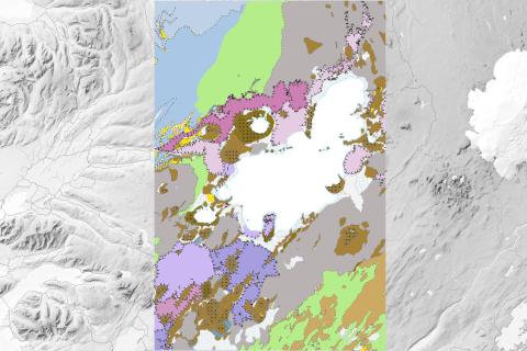
Geological Map of the Western Volcanic Zone (Sveinn P. Jakobsson)
This Geological Map of Iceland‘s Western Volcanic Zone at a scale of 1:100,000 was authored by geologist Sveinn P. Jakobsson and nearly finished when he passed away in 2016. The map was published as part of preparations for the mapping of a similar area by the Icelandic Institute of Natural History and the Iceland GeoSurvey, which culminated in a map published in 2022.
Sveinn‘s map covers an area from Lake Úlfljótsvatn in the south to the Blöndulón reservoir in the north. The map shows bedrock geology (image on left), volcanic formations (image on right), volcanic craters and tectonics. Bedrock is classified by age, type, and composition.
The author of the map is Sveinn P. Jakobsson. The map was published in 2019.
Igneous Rock Series
The map of the three igneous rock series of Iceland at a scale of 1:600.000 shows the volcanic zones active in Iceland and its insular shelf during the Holocene and Late Pleistocene, volcanic systems active during the holocene, the distribution of eruption sites and chemical composition of erupted rocks.
The author of the map is Sveinn Jakobsson. It appears in Sveinn P. Jakobsson, Kristján Jónasson og Ingvar A. Sigurðsson 2008. The three igneous rock series of Iceland. Jökull 58: 117–138.
Surficial Geology Map
The surficial geology map is based on field observations and aerial photo interpretation, along with previous research and older mapping of specific areas. They show the composition and distribution of different surface sediments and landforms, which reflect, among other things, the history of landslides, major source areas, and landslide paths.
Geothermal Map

This geothermal map shows the location, temperature, and nature of geothermal sites at the surface. A distinction is made between heat emerging in the form of water (vatn) and steam (gufa). Carbonic acid springs (kolsýrulaugar) are specially marked. The approximate boundaries of high temperature geothermal areas (háhitasvæði) are shown in magenta. Red triangles indicate locations where there are signs of subsurface geothermal activity, and blue triangles represent known subglacial and submarine geothermal zones. Data on bedrock age, type, and composition comes from the Bedrock geology map (see above).
This map is part of a joint report on geothermal energy prepared in cooperation with the National Energy Authority (Helgi Torfason 2003. Jarðhitakort af Íslandi og gagnasafn um jarðhita. Náttúrufræðistofnun Íslands og Orkustofnun, NÍ-03016; OS-2003/062. 167 pp.) and is in Icelandic only.
Geological maps of Iceland

Geological maps of Iceland at a scale of 1:250,000 (nine sheets). The maps show the main features of the geology of Iceland. Bedrock is classified by age, type and composition. Surficial deposits are classified from postglacial to Holocene. The map also shows the distribution of Pleistocene and postglacial eruption sites, geothermal sites, rockslides, the direction of glacial striae, strike and dip, and the location of fossil finds.
A total of 7 of 9 sheets have been published to date. Publication and revision was ongoing in 1960–1994. Publication of the remaining two sheets is planned for the future, after a long hiatus. The still-unpublished sheets are of mid-north Iceland (4) and mid-east Iceland (8). Revision and digitisation of previously published sheets will also be necessary.